Kingfisher
Regular.
- Joined
- Jul 31, 2008
- Messages
- 384
- Reaction score
- 0
Yesterday I managed to make time to do a walk I've been looking at for some time. It takes in an old railway line high across Stanhope Moor in Co Durham circles through the small ex lead mining village of Rookhope and follows down Rookhopeburn to Eastgate and the main road, around 8 miles.
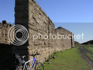
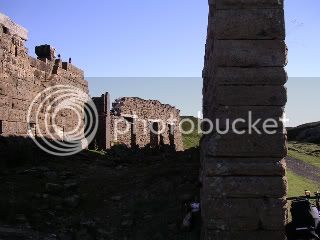
We started where the old railway line intersects the B6278 near Parkhead, which has a cafe and B&B and headed along the old formation to the NW. The line cuts across the rim of the Stanhopeburn valley and gives good views across four adjoining counties and at one spot to the sea. As you approach the summit you come across the remains of the old winding house for Rookhope and Boltslaw incline.

This was the original: http://www.durham-pa.gov.uk/durhamcc/DR ... Lead+mines
The descent into Rookhope is steep and once into the village there's a pub The Rookhope Inn that's flickered on for the past few years under different owners. We didn't stop there but headed down to Eastgate and the Cross Keys.
After leaving Rookhope on the metalled road there a footpath to the east marked Weardale Way. This path follows Rookhopeburn down to the main road. Although very wet and rough in places it passes Brandon Walls lead mine which has a very extensive area left intact with a mine shaft and waterwheel pit. The area is very overgrown and you must look hard to see the remains. From here you follow what was reputedly the old highway from Rookhope to Eastgate
and arrive in the outskirts of that village. If you turn right and again sharp right you cut across Rookhopeburn below the falls,

cross the bridge, through the caravan site, walk down to the road and the pub-----which was shut at 2.00pm on a Friday :!:
We started where the old railway line intersects the B6278 near Parkhead, which has a cafe and B&B and headed along the old formation to the NW. The line cuts across the rim of the Stanhopeburn valley and gives good views across four adjoining counties and at one spot to the sea. As you approach the summit you come across the remains of the old winding house for Rookhope and Boltslaw incline.
This was the original: http://www.durham-pa.gov.uk/durhamcc/DR ... Lead+mines
The descent into Rookhope is steep and once into the village there's a pub The Rookhope Inn that's flickered on for the past few years under different owners. We didn't stop there but headed down to Eastgate and the Cross Keys.
After leaving Rookhope on the metalled road there a footpath to the east marked Weardale Way. This path follows Rookhopeburn down to the main road. Although very wet and rough in places it passes Brandon Walls lead mine which has a very extensive area left intact with a mine shaft and waterwheel pit. The area is very overgrown and you must look hard to see the remains. From here you follow what was reputedly the old highway from Rookhope to Eastgate
and arrive in the outskirts of that village. If you turn right and again sharp right you cut across Rookhopeburn below the falls,
cross the bridge, through the caravan site, walk down to the road and the pub-----which was shut at 2.00pm on a Friday :!: